
Account
Pictures

Catching up

Tandem Club GPX/TCX Rides list
 |
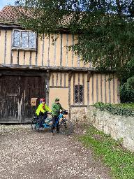
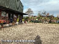
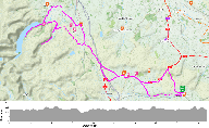
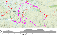
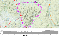
Id: 427, Quality: 5 Group: Yorkshire Location: Pocklington Postcode: YO42 2AH Map Reference: 53.9311, -0.77788 Ride length: 67 km Ride ease: Average Added by: Neil Wheadon | Wolds circular: Lovely 70 km day ride from Pocklington using mainly Sustrans routes and parts of the Yorkshire Wolds cycle way - with long steady climb after lunch but a manageable gradient. The well-known Millington Dale approaching Pocklington towards the end did not disappoint. Early coffee oppor ... |
 |
Id: 1972, Quality: 3 Group: Yorkshire Location: Thorpe Arch Postcode: LS23 7FE Map Reference: 53.9111, -1.32001 Ride length: 32 km Added by: Graham Riley | This is an easy ride from Tim's Cafe at Thorpe Arch Trading Estate, Avenue D, Thorpe Arch, LS23 7FE to Doylys Cafe, Bolton Percy. A mostly flat circular route on a mix of cycle path, quiet country roads with only a short stretch on a busier route, total 20 miles (unless we decide to add a bit on!) M ... |
 |
Id: 1872, Quality: 3 Group: Yorkshire Location: Riccall Postcode: YO19 6QD Map Reference: 53.8331, -1.05853 Ride length: 33 km Ride ease: Easy Added by: Graham Riley | This route takes you from the quiet village of Riccall in North Yorkshire into the centre of York via the Sustrans Solar Sytem Route. The return leg crosses York Racecourse, York Millenium Bridge and, via Fulford, follows quiet lanes through Naburn, Stillingfleet and Kelfield to Riccall. Total 21 Mi ... |
|
Id: 1871, Quality: 2 Group: Yorkshire Map Reference: 53.8331, -1.05853 Ride length: 33 km Added by: Graham Riley | A ride of the full length of the Solar System Route into York from Riccall near Selby, over York Racecourse then via Milleenium Bridge to return via Naburn (for a lunch stop), Stillingfleet and Kelfield. The route will be around 21 miles half on on road Sustrans route, half on quiet country lanes. |
|
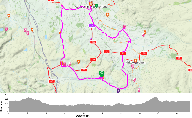
Id: 1802, Quality: 2 Group: Yorkshire Map Reference: 54.0399, -1.56697 Ride length: 39 km Added by: Graham Riley | The ride will start from Ripley Village Car Park, by Ripley Castle, HG3 3AY. Meet from 10:00 for a 10:30 start. The route is circular, 24 miles, with a stop at Fountains Abbey for lunch and on mostly quiet country lanes. There will be a few moderate hills, but otherwise the route should be quite eas ... |
 |
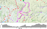
Id: 1180, Quality: 2 Group: Yorkshire Location: Market Weighton Car PArk Postcode: YO43 3AZ Map Reference: 53.8658, -0.6678 Ride length: 58 km Ride ease: Average Added by: Graham Riley | The ride is from Market Weighton to Stamford Bridge and is around 36 miles. The destination for the ride is the Old Station Club/ Heritage Centre. This is home to The Stamford Bridge Tapestry, and has covered heated area for eating packed Lunch. Hot and cold drinks are available to purchase from the ... |
 |
Id: 705, Quality: 2 Group: Yorkshire Location: BA3 5LS Postcode: BA3 5LS Map Reference: 54.4461, -2.45604 Ride length: 75 km Ride ease: Average Added by: Neil Wheadon | |
 |
Id: 704, Quality: 2 Group: Yorkshire Location: BA3 5LS Postcode: BA3 5LS Map Reference: 54.4462, -2.45612 Ride length: 73 km Ride ease: Hard Added by: Neil Wheadon | |
 |
Id: 703, Quality: 2 Group: Yorkshire Location: BA3 5LS Postcode: BA3 5LS Map Reference: 54.4462, -2.45612 Ride length: 46 km Ride ease: Average Added by: Neil Wheadon | |
 |
Id: 702, Quality: 2 Group: Yorkshire Location: BA3 5LS Postcode: BA3 5LS Map Reference: 54.4461, -2.45598 Ride length: 68 km Ride ease: Average Added by: Neil Wheadon | |
 |
Id: 701, Quality: 2 Group: Yorkshire Location: BA3 5LS Postcode: BA3 5LS Map Reference: 54.4462, -2.45611 Ride length: 101 km Ride ease: Average Added by: Neil Wheadon |