
Account
Pictures
Forsale
Tandem Club GPX/TCX Rides list
 |
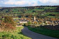
Id: 1939, Quality: 5 Group: tce2026 Location: Ashbourne Campsite Postcode: DE6 3EN Map Reference: 53.0184, -1.649 Ride length: 82 km Added by: Neil Wheadon | Sun_TC5F_Monsal_Trail The NW rides (D, E & F) all begin with some vicious climbs onto the White Peak plateau, then try to stay up there, but cannot avoid falling into the occasional steep-sided dale! Route D to Bradford Dale and Youlgreave, is actually shorter than A, but a bit more hilly. Route E ... |
 |
Id: 1938, Quality: 5 Group: tce2026 Location: Ashbourne Campsite Postcode: DE6 3EN Map Reference: 53.0184, -1.649 Ride length: 69 km Ride ease: Average Added by: Neil Wheadon | Sun_TC5E_Monyash The NW rides (D, E & F) all begin with some vicious climbs onto the White Peak plateau, then try to stay up there, but cannot avoid falling into the occasional steep-sided dale! Route D to Bradford Dale and Youlgreave, is actually shorter than A, but a bit more hilly. Route E exten ... |
 |
Id: 1937, Quality: 5 Group: tce2026 Location: Ashbourne Campsite Postcode: DE6 3EN Map Reference: 53.0184, -1.649 Ride length: 53 km Ride ease: Average Added by: Neil Wheadon | Sun_TC5D_Youlgrave The NW rides (D, E & F) all begin with some vicious climbs onto the White Peak plateau, then try to stay up there, but cannot avoid falling into the occasional steep-sided dale! Route D to Bradford Dale and Youlgreave, is actually shorter than A, but a bit more hilly. Route E ext ... |
 |
Id: 1936, Quality: 5 Group: tce2026 Location: Ashbourne Campsite Postcode: DE6 3EN Map Reference: 53.0184, -1.649 Ride length: 62 km Ride ease: Average Added by: Neil Wheadon | Sun_TC5C_Crom-Mills The SE history rides (A, B & C) all have 11ses at Kedleston Hall (NT) then go up the Derwent Valley by routes that avoid the A6 (and Wirksworth, because it's in a hole!) and re-unite on the High Peak Trail at Black Rocks. Route A goes straight along the E side of a sandstone rid ... |
 |
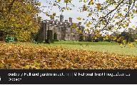
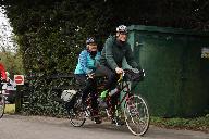
Id: 1935, Quality: 5 Group: tce2026 Location: Ashbourne Campsite Postcode: DE6 3EN Map Reference: 53.0184, -1.649 Ride length: 58 km Ride ease: Average Added by: Neil Wheadon | Sun_TC5B_Crom-Canal RIDDEN AT THE EVENT Head out of the campsite and you are soon into the quiet lanes heading south. These weave south east and you will see some lovely views below you. Kedleston Hall is accessed by a long driveway and the house will appear infront of you. There is a cafe here and ... |
 |
Id: 1934, Quality: 5 Group: tce2026 Location: Ashbourne Campsite Postcode: DE6 3EN Map Reference: 53.0184, -1.649 Ride length: 55 km Ride ease: Average Added by: Neil Wheadon | Sun_TC5A_BlackRocks This route unlike Cromford and the Cromford Canal avoids the first big climb to Middleton Top via the Dingle The SE history rides (A, B & C) all have 11ses at Kedleston Hall (NT) then go up the Derwent Valley by routes that avoid the A6 (and Wirksworth, because it's in a hole!) ... |
 |
Id: 1933, Quality: 5 Group: tce2026 Location: Ashbourne Campsite Postcode: DE6 3EN Map Reference: 53.0184, -1.649 Ride length: 76 km Ride ease: Average Added by: Neil Wheadon | Sat_TC4D_Marchington The main choice is to rail- trail or not, with optional extensions on either. Unlike yesterday: the shortest route A, is all-tar and although its extension B is a bit longer than C (the shortest to include the Great Northern Trail), it should be slightly easier and quicker. Rou ... |
 |
Id: 1932, Quality: 5 Group: tce2026 Location: Ashbourne Campsite Postcode: DE6 3EN Map Reference: 53.0184, -1.649 Ride length: 56 km Ride ease: Average Added by: Neil Wheadon | Sat_TC4C_Tutbury the main choice is to rail- trail or not, with optional extensions on either. Unlike yesterday: the shortest route A, is all-tar and although its extension B is a bit longer than C (the shortest to include the Great Northern Trail), it should be slightly easier and quicker. Route D ... |
 |
Id: 1931, Quality: 5 Group: tce2026 Location: Ashbourne Campsite Postcode: DE6 3EN Map Reference: 53.0184, -1.649 Ride length: 57 km Added by: Neil Wheadon | Sat_TC4B_Sudbury This ride just misses Tutbury, but a small diversion will take tou there. It also bypasses the Great Western Trail The main choice is to rail- trail or not, with optional extensions on either. Unlike yesterday: the shortest route A, is all-tar and although its extension B is a bit ... |
 |
Id: 1930, Quality: 5 Group: tce2026 Location: Ashbourne Campsite Postcode: DE6 3EN Map Reference: 53.0184, -1.649 Ride length: 46 km Ride ease: Easy Added by: Neil Wheadon | Sat_TC4A_Marston on Dove The shortest ride A, is all-tar and although its extension B is a bit longer than C (the shortest to include the Great Northern Trail), it should be slightly easier and quicker. D is longest and includes the trail. As you can see from the map, all routes converge in the Hil ... |
 |
Id: 1929, Quality: 5 Group: tce2026 Location: Ashbourne Campsite Postcode: DE6 3EN Map Reference: 53.0184, -1.64902 Ride length: 99 km Ride ease: Hard Added by: Neil Wheadon | Fri_TC3D_Earl Sterndale Some riders nevertheless prefer the black stuff, so our longer route C (green) goes west to the Manifold Valley and follows a rail trail that is tarmac - albeit bumpy in parts! This route returns over the Weaver Hills to a highly recommended refreshment stop in Denstone. The ... |
 |
Id: 1928, Quality: 5 Group: tce2026 Location: Ashbourne Campsite Postcode: DE6 3EN Map Reference: 53.0184, -1.64902 Ride length: 81 km Added by: Neil Wheadon | Fri_TC3C_Manifold Valley Some riders nevertheless prefer the black stuff, so our longer route C (green) goes west to the Manifold Valley and follows a rail trail that is tarmac - albeit bumpy in parts! This route returns over the Weaver Hills to a highly recommended refreshment stop in Denstone. Th ... |
 |
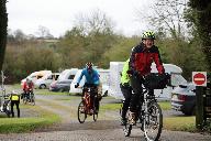
Id: 1927, Quality: 5 Group: tce2026 Location: Ashbourne Campsite Postcode: DE6 3EN Map Reference: 53.0184, -1.649 Ride length: 69 km Ride ease: Easy Added by: Neil Wheadon | Fri_TC3B_Parsley Hay RIDDEN This is a lovely ride. The top extension from TC3A is well worth it as it takes you along 2 beautifil valleys, gradually climbing to the Tissington Trail Route B (blue) extends A slightly, avoiding a steep approach to Hartington Station by taking the gentler and most sce ... |
 |
Id: 1926, Quality: 5 Group: tce2026 Location: Ashbourne Campsite Postcode: DE6 3EN Map Reference: 53.0184, -1.649 Ride length: 63 km Added by: Neil Wheadon | Fri_TC3A_High Peak Tissington The shortest route A (red on PDF map) makes more use of trails to minimise hills and traffic. These trails, by Carsington Water plus the High Peak and Tissington rail Trails, have reasonably good gravel surfaces that should be no problem unless your tyres are very narr ... |
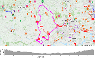 |
Id: 1875, Quality: 2 Group: tce2026 Location: BA3 5LS Postcode: BA3 5LS Map Reference: 53.0184, -1.649 Ride length: 58 km Ride ease: Average Added by: Neil Wheadon | Uses the Great Northern Greenway to visit Tutbury (maybe Castle). Can avoid Greenway by using route 4B to Hilton. |